Taking Emergency Drones to the Front of the Line: How NASA is Prioritizing First Responders in Crowded Skies
As commercial drones become as common as delivery trucks in our neighborhoods, emergency drones—used by police, fire, and rescue teams—need a way to cut through the traffic. That's why NASA, working with Texas public safety agencies, industry partners, and the Federal Aviation Administration (FAA), recently tested an airspace prioritization system in North Texas. This system gives first responder drones the same kind of priority that ambulances and fire trucks get on the road. The exercise showed how technology can let emergency drones move quickly and safely through crowded skies, even when their flight paths are unpredictable.
What exactly happened during the Texas flight exercise?
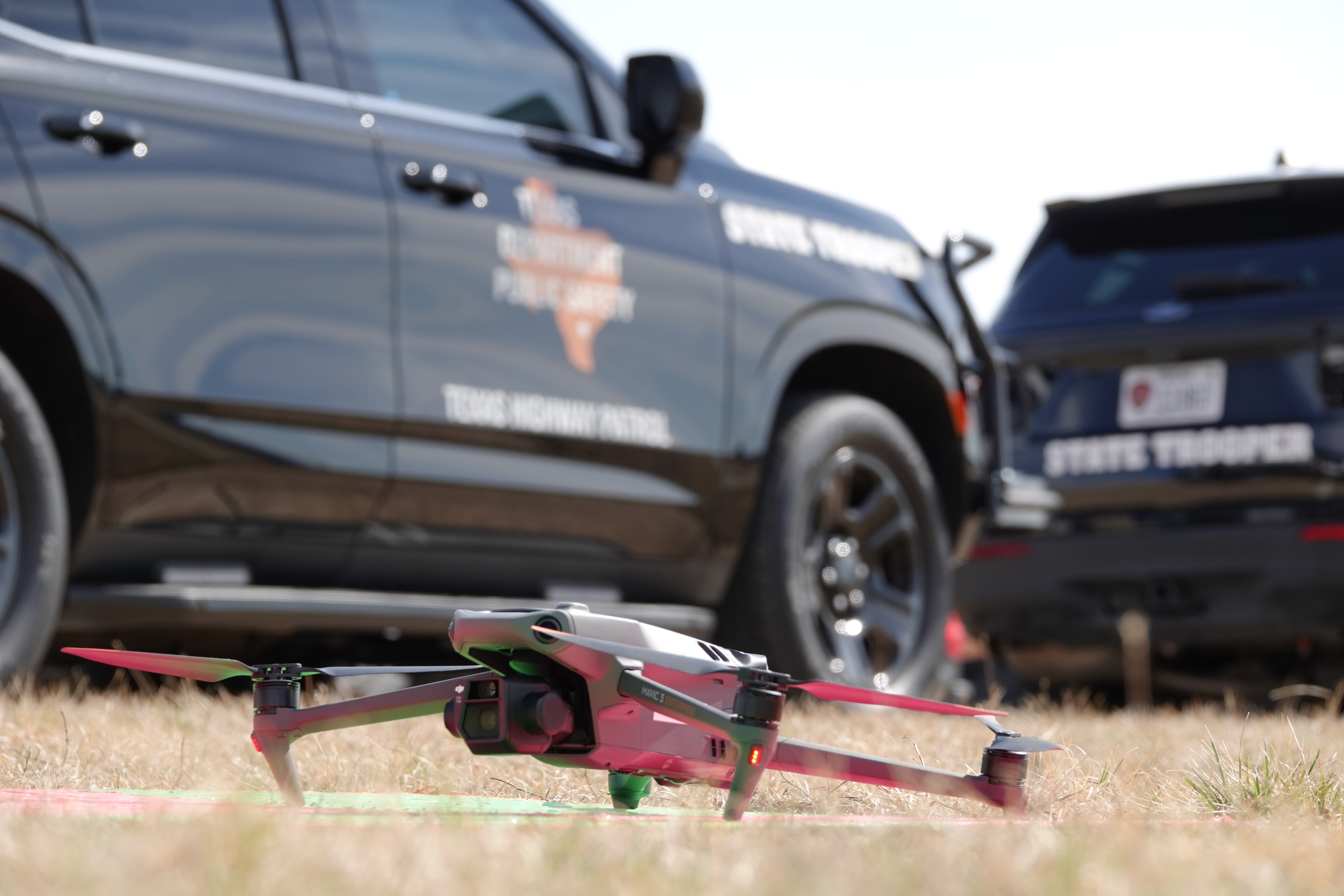
On February 18 in North Texas, a coalition of NASA researchers from Ames Research Center, Texas public safety organizations, industry partners, and the FAA gathered to test how first responder drones can gain priority access to busy airspace. During the exercise, when a police, fire, or rescue drone launched, other commercial drones in the area were instructed to move aside. In scenarios with multiple public safety agencies responding to simulated emergencies, officials coordinated in real time to decide which drone had the highest priority. This demonstrated that airspace prioritization tools can work effectively even when multiple emergency missions compete for the same skies. North Texas was chosen because it's an FAA-designated region where commercial drone deliveries already operate daily, making it a realistic testbed.
How does airspace prioritization for emergency drones work?
Think of it like the lights and sirens on a ground ambulance: when an emergency vehicle approaches, other drivers pull over to clear a path. In the drone world, NASA's system uses digital communication to alert nearby commercial drones that a priority mission is underway. During the test, as soon as an emergency drone took off, other drones in the vicinity received a signal to yield—either by landing, hovering, or rerouting. The system also allows public safety operators to communicate among themselves, so if multiple agencies are responding to an incident, they can negotiate which drone needs the highest priority. "The key is to prioritize safety of flight operations, while balancing the efficient use of the airspace for all operators," said NASA research lead Abhay Borade. This ensures that emergency missions aren't delayed by routine delivery drones.
Why are public safety drone flights more unpredictable than commercial ones?
Commercial drones—like those delivering packages—follow pre-planned, predictable routes. In contrast, first responder drones rarely fly a straight line. During a search for a missing person, a pursuit of a fleeing suspect, or when scanning a hazardous scene after a chemical spill, operators may need to change direction instantly. The Texas exercise included a simulation where a drone had to follow an officer driving an SUV erratically, mimicking a vehicle chase. Such unpredictable maneuvers make it challenging for standard air traffic management systems, which expect set paths. That's why NASA's prioritization tool is designed to handle sudden changes without disrupting other air traffic. By testing these erratic movements, researchers collected data on how nearby commercial drones react and how to safely deconflict the airspace in real time.
What kind of data did NASA collect from the exercise?
Researchers focused on measuring how unpredictable public safety drone movements affect nearby commercial drone operations. In one test, a drone tracked an SUV driving erratically to simulate a police chase—recording flight paths, speed changes, and reaction times. They also monitored how commercial drones responded when notified of a priority mission, noting the time it took for them to clear the area and resume operations. This data helps NASA build better air traffic management systems and tools that can prioritize public safety operators as commercial drone usage grows. Understanding these interactions is crucial for developing frameworks that are safe, responsible, and scalable for everyone involved, as Shivanjl, a NASA project lead, emphasized: "By working closely with industry and federal partners, we're building the data, tools, and traffic management frameworks needed to ensure the future of drone operations is safe for all."

How does drone priority compare to ground emergency vehicles?
On our streets, emergency vehicles use lights and sirens to signal other drivers to yield. In the sky, there are no flashing lights or audible sirens that drones can recognize. Instead, NASA's system uses digital signals transmitted through airspace management software. When an emergency drone launches, it sends a priority request to the network, which then instructs commercial drones to vacate the area or adjust their flight paths. This is the aerial equivalent of cars pulling over to the shoulder. The Texas test showed that this digital right-of-way works effectively, even when multiple priority requests come in at once. The goal is to make the skies as safe for first responders as the roads are—while also ensuring that commercial drone deliveries can continue smoothly around them. NASA's approach balances public safety needs with efficient airspace use, just as traffic lights and road lanes balance safety and flow on the ground.
What does this mean for the future of drone traffic management?
As commercial drones become ubiquitous—delivering everything from food to medicine—the airspace above our cities will get crowded. Without a system to prioritize emergency missions, a life-saving drone could get stuck behind a delivery drone, causing dangerous delays. The success of the Texas exercise shows that NASA's airspace prioritization tools are viable for real-world use. The next steps involve further testing, refining the software, and working with the FAA to integrate these capabilities into national airspace regulations. For public safety agencies, this means faster, safer drone responses to fires, medical emergencies, and law enforcement incidents. For drone operators, it means predictable rules for sharing the sky. The ultimate vision is a scalable traffic management system that automatically gives first responders the clearance they need, just as our roads have done for decades.
Related Articles
- How to Analyze Ransomware Threat Landscape Data: A Q1 2026 Guide
- Ransomware Ecosystem Tightens: Top 10 Groups Control 71% of Attacks in Q1 2026
- Embracing Finite: The Discrete Universe of Doron Zeilberger
- How NASA's Psyche Mission Captured Mars During Its Gravity Assist: A Step-by-Step Technical Breakdown
- Samsung Plans July Launch of AI Smart Glasses to Beat Apple
- 10 Critical Revelations from The Gentlemen RaaS Database Leak
- SpaceX Grants Anthropic Access to Record-Setting AI Supercomputer, Orbital Compute Talks Underway
- The Power of Thinking Time: How AI Models Benefit from Extended Computation